Bulusan Volcano Natural Park
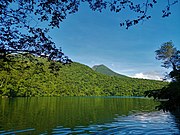
Protected area in the PhilippinesThe Bulusan Volcano Natural Park is a 3,673-hectare (9,080-acre) protected area of rainforest surrounding Mount Bulusan in the Philippines. It was first designated as a National Park by Proclamation no. 811 on June 7, 1935. Under the National Integrated Protected Areas System (NIPAS) of 1992 managed by the Department of the Environment and Natural Resources, the park was reclassified as a Natural Park by Proc. 421 on November 27, 2000. The area features the volcano itself, Bulusan Lake, the two other mountains known as the 'Sharp Peak' and 'Hormahan' and Lake Aguingay. The park is in the south central part of Sorsogon Province, southern Luzon, Bicol Region, Philippines, bounded by five municipalities: Bulusan, Barcelona, Irosin, Juban and Casiguran.
Read article


.svg)


Top Questions
AI generatedMore questions
Nearby Places

Bulusan (municipality)
Municipality in Sorsogon, Philippines

Irosin
Municipality in Sorsogon, Philippines

Mount Bulusan
Volcano in the Philippines
Lake Bulusan
Crater lake in Luzon Island
Lake Aguingay
Seasonal crater lake in Luzon Island
Bulusan High School
Public high school in Sorsogon, Philippines
Bulusan National Vocational Technical School
School in Sorsogon, Bicol Region, Philippines